Showing posts with label Maps. Show all posts

Sunday, June 30, 2013

My Homebrew Setting

I have posted before about various setting ideas. I have also posted about my world, Aranor. I first started mapping and writing about Aranor in 1990. I have written quite a bit in the last 23 years, unfortunately much of it is mutually exclusive. My gaming ADD takes a heavy toll on any setting development I am involved in. I am sad to say that I typically try to fit Aranor to the rules, rather than the other way 'round.

My vision (if it could be called such) has always been more tilted to swords and sorcery, but with some higher fantasy elements. Not many, but some. Whenever my attention shifts, it is inevitable that I will drag Aranor into it sooner or later. So it has happened with Dungeon Crawl Classics. I am hoping that I can settle on DCC and really get some deeper, sustained development going. The particular conceits of DCC seem to really fall into line with what I want in Aranor, so this should work well. As long as my attention doesn't drift.

With all that out of the way, I want to offer a new version of a particular region of the map. Below is a larger, hand-drawn, map of Northern Calanthas, one of the main areas. The black box indicates the area detailed in the map that follows.

Below is the detail of the area. The principle adventuring setting is the town and keep of Ravenhold, located in the 4-hex mountainous area to the SE of the lake. I haven't placed settlement symbols or names on the map yet.

As you can see, I rendered the map in the style of the old Judge's Guild maps. I thought it made a nice fit for a DCC setting. Besides which, I just like that style. It is very evocative and nostalgic. I did it using GIMP and some patterns that I downloaded from here.


Friday, June 8, 2012

A "New" Blog

I ran across this blog today: RPG World Building. This is a subject near and dear to my dark little heart. October is doing some great work, and her site is well worth the trip.

Wednesday, May 23, 2012

Mapping for the Masses

I love maps, I always have. In fact, it was a brief, yet tantalizing, glimpse at a dungeon map that first piqued my interest in D&D (although I had no idea the map was a dungeon map at the time). I have always tried to make my maps functional and accurate, and as my meager abilities allowed, artistic. I have explored countless shading and symbol variants when hand-drawing. I've also experimented with a lot of software tools for mapping.
It has started occurring to me that I want to explore an entirely different mindset. I want to try approaching my cartography from a new Starting point, as it were. Consider the following:
  • Maps were not mass produced. Each was a one-of-a-kind deal.
  • Not only was each map uniquely created, the information it contained was arrived at individually. So, even if separate missions explored the same area, the maps would likely be quite different.
  • Most maps were driven by mercantile enterprises.
  • Considering that explorers were exploring for the purpose of opening new markets and sources of trade, the maps their travels generated should be considered akin to trade secrets.
  • Being driven by economic interests, especially related to sea-trade, coastal detail, including ports-of-call and safe harborages, would be of utmost importance.

All of these thoughts has led me to the idea that I want to make my maps more artistic. I've always wanted my mountain symbols, for example, to occupy the proper amount of space, according to the scale I've established. I want to change that. I want terrain symbols to be representative of the terrain that is most likely to be found in the surrounding area.


Another common theme in antique maps are little artistic embellishments. People going about some sort of activity, perhaps tied to local tradecraft or terrain, were quite popular. Farming, herding, hunting, and trade caravans appear frequently. I really like that idea.

Ultimately, the map is a method of communication. Typically, it would have been the map-maker communicating with himself, a device whereby to remember the lay of a land, treacherous sea-lanes or dangerous shoals, or pictographic clues about the peoples found in a particular location. They could be covered in specific notes, perhaps in a personal code.

Finally, I need to stop thinking of maps as being mass-produced and each consistent with the next. Maps for characters should be rare and treated as treasure. What price can be placed on a map through a monster-infested wilderness, sure to befuddle even the most seasoned traveller? Such a map that could virtually guarantee not getting lost, thus saving wandering lost for perhaps days.

Friday, May 11, 2012

Northern Calanthas with Rivers and Cities

Northern Calanthas with Rivers and Cities
Here is an updated map, including rivers and cities. Now, only roads and labels left to do.

Thursday, May 10, 2012

Aranor Hex Map

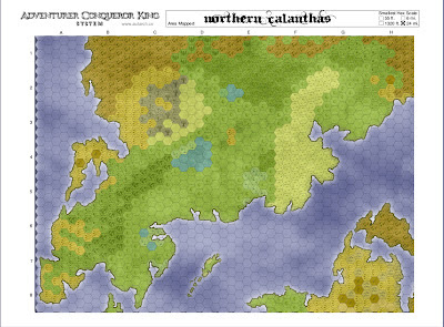
Northern Calanthas Hexmap
Here is an early draft of my campaign setting, rendered on an ACKS hex grid, for sandbox purposes. I used hexGIMP (available here). The download includes a brush folder and a script for generating the blank hex map. Even though the ACKS sheet already has a hex grid, I couldn't get the brushes to properly fit. The brushes scale proportionately, but the hexes aren't proportionate to them, so it was pretty fugly. I ended up saving the border from the ACKS sheet and pasting it onto the grid generated by hexGIMP. I had to scale it around the map, but that was easy. If anyone tries this and has any trouble, I'll be happy to offer whatever advice I can.

This level of map is mainly a reference for greater detail hexcrawl development. I'm still pretty happy with it so far, just on its own merits. I still have to add rivers, roads, settlements, and labels.

Monday, May 7, 2012

My Campaign World

Alright, here we go. This is a world I've worked on, off-and-on, since sometime around 1990 or '91. It has gone through certain changes, including maps and writings, over the years. Mostly due to trying to warp it to fit whatever system I've been enthralled by at the time. I can't even count how many times I've picked it up and put it down again. Now, I've picked it back up. I'm not going to warp it anymore. I believe the LBBs are flexible enough to fit right in without requiring the setting to reflect certain unalterable aspects of the rules.

Now that the preamble is out of the way, here is the basic map of Northern Calanthas, the principle campaign area. It has seen the most specific development. It is the northern half of an island-continent (most of the continents are island-continents), which is divided by the Sundering Sea. The "d" in Sundering is hard to see on the map because I forgot to write it.

Northern Calanthas


I've also added a brief introduction to the Northlands to my Pages section, so be sure to grab that to go with the map. I have a lot of stuff written for this. It is in various stages of development, and reflects my interest in a number of systems. My goal is to post it as I get it at least a little cleaned up (hopefully polished), and stripped of specific system references. Please feel free to offer any comments or thoughts.

Wednesday, May 2, 2012

Color Maps

Northeast Corner
As promised, here are the City State Campaign One maps, hand-colored by yours truly. When I split the map into four I tried to allow some overlap to make a more seamless re-assembly.

Southeast Corner

I'm afraid I must admit to something. In this NE corner map I did not realize the symbols along the coast and rivers indicate beach/sand. I thought they were just fairly narrow bands of forest along water. I realized my mistake on the other three maps and corrected it. On the whole, though, I rather like the narrow bands of forests. In retrospect, I wish I'd done more of a mix of the two.

Northwest Corner

My only real issue with these maps is that the names on it are hard to read, and the settlement symbols are a little vague. I may clean those up by hand, I'm not sure. Then again, coloring these was quite relaxing. I may just open the B&W images in GIMP and re-label things and throw in some new settlement symbols while I'm at it. That could be fun. If I do, I'll upload those B&W in case anyone wants to color their own.

Southwest Corner
As I was coloring these, something occurred to me. Most of the stuff from Judges Guild has the old school "make it your own" mentality. There's not much that could really be considered "canon". In a way, coloring these maps for myself follows that philosophy quite well. Hell, I colored coast as forest, and I will again. Once I get the maps back into GIMP I can make other changes if I want. The great thing is, I can make almost any change I want and not have to worry about violating some description or write-up. At the risk of sounding self-important, this almost feels like a collaboration. It definitely feels like fun.

Monday, March 19, 2012

Ailoria: A New Map

This is a hand drawn sketch (obviously) of a new setting/world. I was waiting for my wife at an appointment she had Saturday morning, and it just came to me. It's going to be a gritty, S&S themed thing. I feel awkward over what to call it. I hate calling it setting because that, to me, connotates something designed as a backdrop for a specific purpose. I don't feel comfortable with world either, because obviously, it isn't. Besides, I know me, if I start calling it world, then I'll feel compelled to venture beyond the confines of this map. I want to keep my efforts focused here.

Anyway, I'm going to develop it along the lines of the small-kingdom concept I discussed in this thread. I'll also be trying out the Welsh Piper's Hex-based Campaign Design.

Speaking of it being gritty S&S, I've come to realize something. I don't want pure, true-to-the-sources S&S. I want an S&S style, but I don't want to throw out the baby with the bathwater. I still want some classic D&D tropes. Some. For example:
  • I don't want the chief adversaries to be limited to humans. I want monsters.
  • I don't want to have to make up some horror lost to time, in order for the adventure to truly have a monster
  • At the same time, I don't want to have to consider the implications of orcs having their own nations. Monsters exist, but mainly as antithesis to civilization and the forces of Law. They are the Bad Guys, and are not to be trusted.
  • Lastly, I want to allow for good, old-fashioned dungeon crawls. I don't want every adventure to be a case of sneak-in-without-getting-caught, grab the loot, and run-out-before-we get-killed.
So, there it is. This will be my design log, which I'm sharing in hopes of getting feedback that will help me do this the best I can. This map is the starting point. I'm going to port it into GIMP and try to pretty it up. That will be submitted for comment, as well.

PS> The name is pronounced EYE-loria.

Tuesday, March 13, 2012

State of Mapping Art


As gamers, we enjoy mapping and cartography resources formerly available only to professional publishers and print houses. Now, we have the likes of dedicated fantasy cartography software, such as Campaign Cartographer and Dundjinni, for those willing to pay. There are free-to-use web based mappers, like Hexographer. Then there are more general purpose imaging programs, like Photoshop, or the free alternative GIMP, for those willing to bend the software to their will.

I have used many of the software options available (believe me, there are many more than I listed). A competent operator can generate beautiful, professional grade maps of his setting of choice. The real advantage is the ability to make changes, corrections, and modifications to the maps with relative ease. Through the clever use of layers these maps can contain an atlas' worth of maps in a single file. Scaling is not a concern when "zooming in" to produce local maps from regional overviews. There are a ton of advantages to using these software options, and I won't decry any of them.

Nothing gets me in a gaming mood like a hand drawn map, though. Give me a hex sheet, like these from Welsh Piper, and a fistful of colored pencils, and I am in heaven. For me, there is some sort of intimate connection with the environments, lands, and peoples when I draw the map by hand. The map comes alive for me when I'm not having to "figure out" how to draw it.

Like I said, I'm not decrying the software. I enjoy making maps with GIMP. It's just a different enjoyment, and not quite as personal. As beautiful as the maps can be, software maps always have a certain degree of sterility to them. I swear I'm not saying that to be negative, it just contrasts with the deeper, investment-type enjoyment I get from hand drawing my maps.

The scaling thing I mentioned earlier isn't nearly so convenient by hand, but know what? That's ok, too. I've come to embrace the notion that I can explain differences in scale and other inconsistencies between maps as different cartographers. I've also moved away from serious scales. I find it far more immersive to describe scale loosely and rely on local concerns to define it. A map that covers a region encompassing a town and its attendant villages would like have a scale defined in days of travel, for example.

Of course, there is no reason that both media can't be used in tandem. I like the idea of using something like Fractal Terrain to lay out the "big picture" on a global scale, then hand drawing the areas of interest.

There are a lot of tools out there for campaign mapping, no matter what game or genre you're into. When you're trying to decide what to use, though, don't forget good ol' pencils and paper. As they say in baseball, "Dance with the one that brung you."

Friday, March 2, 2012

A Quick Idea

 
I was printing out B1 and B2 (hopefully I can get someone to play, now that my dice are back). One thing that concerned me was the blue saturation on the maps. So, I came up with what I think is a good solution, and I wanted to pass it along. I opened the pdf in Okular and performed the following operations in GIMP, but I'm sure Photoshop would work, too.

  1. Open the pdf and rectangular-select the entire map page. Copy to the clipboard.
  2. Start GIMP, and select Edit -> Paste.
  3. Using the Fuzzy Select tool, click anywhere in the mass of blue. If there are disconnected areas, you can add them to the selection set by holding down Shift and clicking those areas.
  4. Once you have the blue masses selected, click Select -> Shrink. Shrink the selection by 3 pixels (my preference, you may want something heavier or lighter).
  5. Click the Delete button on the keyboard.
Performing the above operations on the above map yielded this result:


It is still blue, but it won't chew up your ink cartridge to print all that unnecessary blue mass.

Oh, one more thing: pay attention to scale. Copying it into GIMP that way can make it wonky. I performed the following steps before I printed:
  1. Click Select -> None
  2. Click Image -> Scale Image
  3. Set Resolution to the desired level (I used 200)
  4. Change Image Size units to Inches (or whatever you're most comfortable with)
  5. Change Width to 7.5", making sure Height remains proportionate

And there you have it. It only takes about 2 minutes, start to finish, and will save a lot of ink.